GoldHaven Resources Commences Auger Drill Program at the Copeçal Gold Project in Mato Grosso, Brazil
VANCOUVER, British Columbia, June 10, 2025 (GLOBE NEWSWIRE) -- GoldHaven Resources Corp. (“GoldHaven” or the “Company”) (CSE: GOH) (OTCQB: GHVNF) (FSE: 4QS) is pleased to announce the commencement of the Auger Drill program at its 100%-owned Copeçal Gold Project located in the prolific Juruena Terrane, Mato Grosso State, Brazil. Building on momentum from prior announcements, the Company’s geological team has been busy on-site confirming Auger Drill Rig access, finalizing the grid location and establishing accommodations for the full crew during the program. Yesterday, June 9th, the drill rig began turning on the planned 2,000m Auger Drilling Program, designed to enhance geological understanding to support future diamond drilling campaigns.
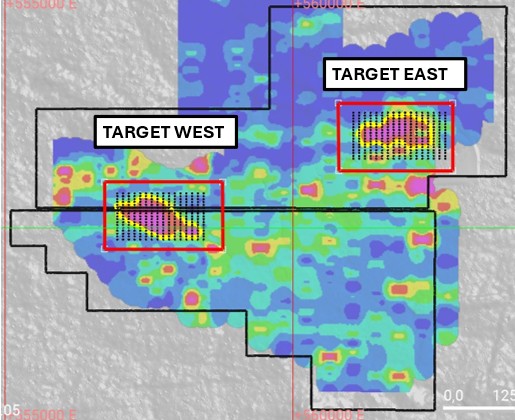
Figure 1: Copeçal Project showing the location of the Priority East and West Targets with planned Auger Drilling Grid (black dots) and VLF Drone Magnetics (Red flight plan polygons)
The Auger Drilling Program will focus primarily on defining a 3D litho-geochemical footprint of gold distribution within the regolith profile beneath the extensive East Gold-in-Soil Anomaly. Vertical auger holes will be drilled systematically from surface to the regolith-bedrock interface—expected to range between 5 to 30m in depth—on a tight 100m x 50m grid. This methodical approach is expected to generate high-resolution data critical for the refinement of subsurface geological and structural models.
In addition to the East Anomaly, the Company will test several other zones of gold anomalism that align with interpreted structural trends, further leveraging the favourable geology observed across the Copeçal Project area.
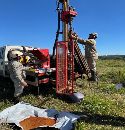
Figure 2: Image from the Copeçal Auger Drill program highlighting the Truck mounted mechanical Auger Drill Rig being used to advance litho-geochemical modeling of the East Target
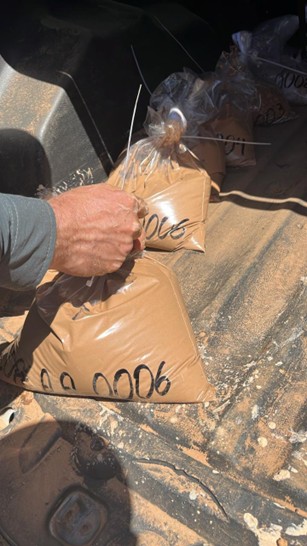
Figure 3: Soil samples collected from the Copeçal Gold Project’s eastern anomaly during the Auger Drill program
Looking ahead, GoldHaven anticipates launching a Drone-borne Very Low Frequency (VLF) Electromagnetic Survey in early July (referred to in Figure 1). This survey will target the structural trends believed to be favourable hosts to gold mineralization, covering both the East and West Gold-in-Soil anomalies as well as their potential strike extensions. The integration of VLF geophysics with auger geochemistry will provide a robust framework for finalizing diamond drill collar locations, thereby maximizing the efficiency and effectiveness of future drilling campaigns.
Rob Birmingham, CEO of GoldHaven Resources, commented: “We are excited to enter the next phase of exploration at Copeçal. The combination of high-resolution auger geochemistry and drone-based geophysics places us in a strong position to accurately delineate high-priority targets. This integrated approach is designed to de-risk our diamond drilling program and unlock the project’s full potential. The Company remains committed to advancing its Brazilian exploration portfolio in a disciplined, data-driven manner, leveraging best-in-class techniques to generate value for shareholders.”
About the Copeçal Gold Project: A Brief History
The Copeçal Gold Project is strategically situated within the Alta Floresta Gold Province, a historically productive region that has yielded substantial gold discoveries since the late 1970s. GoldHaven’s tenements cover a total of 3,681 hectares in a geologically favourable setting within the Juruena Gold Province of Brazil.
The Juruena Gold Province, also known as the Juruena Magmatic Arc, is an orogenic belt highly prospective for mesothermal shear-related and intrusion-related gold deposits, such as G-Mining’s Tocantinzinho deposit. Additionally, the region hosts recently identified porphyry-style deposits (e.g., Serabi, Jaca) and epithermal-style deposits (e.g., X1, Aura). The presence of multiple deposit styles, along with the confirmation of large-scale gold deposits in the Juruena Province of Brazil, underscores the significant potential of the Copeçal Gold Project.
Recent exploration programs, including geochemical soil sampling, drone-mounted magnetometry surveys, and historical drilling data, indicate the presence of multiple gold-bearing structures. Notably, AngloGold Ashanti previously conducted systematic exploration on the property from 2010 to 2016, including auger and air-core drilling, geophysical surveys, and rock geochemistry, identifying multiple zones of anomalous gold mineralization.
The Copeçal Gold Project benefits from extensive historical work, with AngloGold Ashanti’s exploration confirming gold and arsenic anomalies, indicative of significant mineralization potential. Soil sampling grids and follow-up auger drilling in key areas revealed consistent gold values over wide zones, further supporting the presence of a substantial mineralized system.

Figure 4: Location of the Copecal Gold Project within the prolific Juruena Gold Belt
About GoldHaven Resources Corp.
GoldHaven Resources Corp. is a Canadian junior exploration Company focused on acquiring and exploring highly prospective land packages in North and South America. The Company’s projects include (i) the flagship Magno Project, a district-scale polymetallic property adjacent to the historic Cassiar mining district in British Columbia; (ii) the Three Guardsman Project, which exhibits significant potential for copper and gold-skarn mineralization; (iii) the Copeçal Gold Project, a drill-ready gold project located in Mato Grosso, Brazil with a 6km strike of anomalous gold in soil samples; and (iv) three critical mineral projects with extensive tenement packages totalling 123,900 hectares: Bahia South, Bahia North and Iguatu projects located in Brazil.
Qualified Person:
The scientific and technical information disclosed in this document has been reviewed and approved by Jonathan Victor Hill, B.Sc. Hons, FAusIMM, a Qualified Person consistent with NI 43-101 and Country Manager of GoldHaven.
On Behalf of the Board of Directors
Rob Birmingham, Chief Executive Officer
For further information, please contact:
Rob Birmingham, CEO
www.GoldHavenresources.com
info@goldhavenresources.com
Office Direct: (604) 629-8254
The CSE and Information Service Provider have not reviewed and does not accept responsibility for the accuracy or adequacy of this release.
Forward-Looking Statements
This news release contains “forward-looking information” within the meaning of applicable Canadian securities legislation. Often, but not always, forward-looking information and information can be identified by the use of words such as “plans”, “expects” or “does not expect”, “is expected”, “estimates”, “intends”, “anticipates” or “does not anticipate”, or “believes”, or variations of such words and phrases or state that certain actions, events or results “may”, “could”, “would”, “might” or “will” be taken, occur or be achieved. Actual future results may differ materially. In particular, this news release contains forward-looking information relating to the Company and the Property. The forward-looking information reflects management's current expectations based on information currently available and are subject to a number of risks and uncertainties that may cause outcomes to differ materially from those discussed in the forward-looking information. Such risk factors may include, among others, but are not limited to: general economic conditions in Canada and globally; industry conditions, including governmental regulation and environmental regulation; the availability of capital on acceptable terms; the need to obtain required approvals from regulatory authorities; stock market volatility; competition for, among other things, skilled personnel and supplies; incorrect assessments of the value of acquisitions; geological, technical, processing and transportation problems; changes in tax laws and incentive programs; failure to realize the anticipated benefits of acquisitions and dispositions; and the other factors. Although the Company believes that the assumptions and factors used in preparing the forward-looking information are reasonable, undue reliance should not be placed on such information and no assurance can be given that such events will occur in the disclosed time frames or at all. Factors that could cause actual results or events to differ materially from current expectations include: (i) adverse market conditions; and (ii) other factors beyond the control of the Company. New risk factors emerge from time to time, and it is impossible for the Company’s management to predict all risk factors, nor can the Company assess the impact of all factors on Company’s business or the extent to which any factor, or combination of factors, may cause actual results to differ from those contained in any forward-looking information. The forward-looking information included in this news release are made as of the date of this news release and the Company expressly disclaims any intention or obligation to update or revise any forward-looking information whether as a result of new information, future events or otherwise, except as required by applicable law. Additional information identifying risks and uncertainties that could affect financial results is contained in the Company’s filings with Canadian securities regulators, which are available on the Company’s profile at www.sedarplus.ca.
Images accompanying this announcement are available at
https://www.globenewswire.com/NewsRoom/AttachmentNg/aced8d3b-a75e-46d9-a76c-ceda4fffc9eb
https://www.globenewswire.com/NewsRoom/AttachmentNg/352aeb7d-1aa1-42bc-8cd8-b5b2e1a05cc2
https://www.globenewswire.com/NewsRoom/AttachmentNg/50020364-813e-4f94-aa58-30eca66de879
https://www.globenewswire.com/NewsRoom/AttachmentNg/66893e79-449e-476a-8112-0d022053d346

![]()
Figure 1

Copeçal Project showing the location of the Priority East and West Targets with planned Auger Drilling Grid (black dots) and VLF Drone Magnetics (Red flight plan polygons)
Figure 2
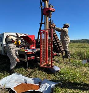
Image from the Copeçal Auger Drill program highlighting the Truck mounted mechanical Auger Drill Rig being used to advance litho-geochemical modeling of the East Target
Figure 3

Soil samples collected from the Copeçal Gold Project’s eastern anomaly during the Auger Drill program
Figure 4
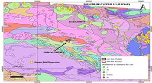
Location of the Copecal Gold Project within the prolific Juruena Gold Belt
Legal Disclaimer:
EIN Presswire provides this news content "as is" without warranty of any kind. We do not accept any responsibility or liability for the accuracy, content, images, videos, licenses, completeness, legality, or reliability of the information contained in this article. If you have any complaints or copyright issues related to this article, kindly contact the author above.
